|
Before giving up completely, I figured it couldn't hurt to explore the
other side of the brook, even though the blaze didn't seem to point that
way. It even looked like there may have been a few old faded tracks in that
direction. After scrambling up a steep bank, winding my way uphill and to
the left, I stumbled across another blaze. I couldn't believe it! You
can't always trust the way the blazes are painted on the trees. They
obviously weren't reliable indicators of the real direction of the trail.
I
was determined to make the summit, but I was also nervous that I might not
be able to. If I had lost the trail once, I could lose it again. The trail
wound upward through open woods. Sometimes I'd be lucky, and I'd see the next
blaze; sometimes I'd have to hunt for it. Finally, I came to a point where
the trail seemed to turn to the right. But after climbing in that
direction for awhile, I unexpectedly reached a dead end. I backtracked to the
last blaze and tried again, searching desperately for a faint blaze that I
might have missed as I
retraced my steps upward. I was certain that I was going the right way but
had just missed some small turn.
This
went on for the better part of an hour. I was exhausted, and returned to
rest where I had lost the blazes. After having a snack and a drink, I
figured I'd give it one last try before giving up and heading home. So I
tried a direction that went more-or-less straight uphill. Again, the blaze
mark did not point this way, but I'd tried everything else. I kept
struggling uphill, hoping to reach what I thought might be a plateau a
little ways ahead. But
before I even got all the way to the level area, I suddenly came upon another blaze. To
me, it was nothing short of a miracle. Three more blazes and I reached the
junction of the A-Z Trail and the Mt Tom Spur. I had been so close for
awhile, it would have been a shame if I had given up.
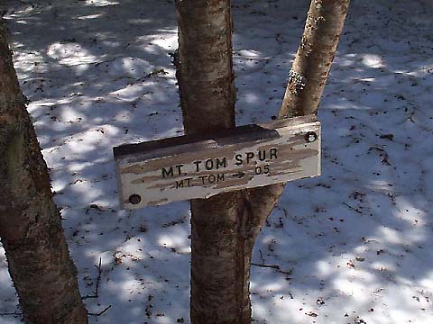
Hoping
that the Mt Tom Spur would be better marked than the A-Z Trail, I took a
picture of the sign, then turned right and started following the trail gently uphill.
There were no blazes at all along this section, but the woods were thicker
here, and the path was more obvious. Because of the shade, there were even
faint markings in the snow from previous hikers, although they certainly
weren't new. The trail went fairly straight for a distance, then came to a
more open area where there were many trees with lichen growing on them.
In
what seemed like a short time, I reached an area that looked like it
might be the summit, although I knew from the reading the guidebook that
the true summit was still just a bit further. Finally, I came out of the woods
onto the small open summit of Mt Tom. The last push uphill on the Spur trail
was so easy, reaching the top was almost anticlimactic. But since Mt Tom
is basically considered a wooded summit, I considered its views on this
sunny day to be highly underrated. |
Mt
Tom Spur Trail sign. I was very happy to see this sign after almost giving
up due to lack of paint blazes along the trail. |
|