|
The afternoon was getting
late, the bottom of the slide was a still mile hike and 1500 vertical
feet below us, and 13 Falls was yet another 3-½ miles away along an
unknown portion of the Lincoln Brook Trail, so after taking a quick look
around, we headed back down. The wooded portion of the trail went by
quickly, but the slide was another matter. The guidebook had said that
it was better to descend on the loose scree than on the ledgy sections,
but after slipping and sliding uncontrollably several times, we shifted
over to the south side of the slide where the firmer rock was. Once at
the bottom, I found my pack and we were on our way again, but the
satisfaction of having attained this remote summit would soon prove to
be short-lived.
Around
the first bend in the trail, we drew close to the stream bank, in fact,
directly up to the edge. But instead of hugging the stream as I had
expected, the trail seemed to veer off uphill to the right. About halfway
up this short incline, the trail appeared to be petering out. We stopped.
Not wanting to waste energy lugging the pack up and down, I took it off,
then went on ahead to check for the right way. But the trail seemed to
split two ways. The right fork got rockier and rockier, soon looking more
like a stream bed than a trail, while the left fork disappeared into a
patch of ferns.
Okay,
I thought. I’ll go back a ways a take another look. So I returned to where
the trail had hugged the stream bank. Did it cross here? There didn’t
seem to be any logical way of descending the steep bank, nor was there
any sign of a path on the other side. And it certainly didn’t continue
straight along the stream through the thick undergrowth. I returned to
where I had left my pack again, giving the route ahead another, closer
look. Did I miss something? No, I didn’t think so. I went back and forth
like that several times, checking and re-checking for anything I may have
missed. The thought crossed my mind that I might have to set up camp here
and try again tomorrow; either that or go back the way I came and admit
defeat at reaching 13 Falls and any other peaks.
Finally, I put the pack back
on and plunged ahead, trying out the rocky stream bed-looking route. At
first, I began to think that it might go somewhere. At one point, it
even looked more trail-like again. In fact, it definitely was a path,
but what a strange course up and down the banks of a couple of dry
tributaries, very untrail-like. After dropping down into another
semi-dry tributary, it came to an abrupt end. To the left, the creek bed
went through the brush and dropped off into Lincoln Brook. That wouldn’t
work.
|
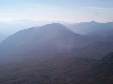
Owl’s
Head mountain looking south from Mt Garfield on a
nice day in the fall. The Lincoln Brook valley, to the right of Owl's
Head in this photo, is the area in which I wandered, trying to follow the Lincoln Brook Trail in
the rain. The Owl’s Head slide is not visible in this photo. You can see the
pointed summit of Mt Flume in the distance. 13 Falls is out of
sight, below and to the left. |
|