|
The
next morning we woke up bright and early, taking down camp in a half
hour. Before leaving, we stopped at the dining area to
retrieve the bear bag. I ate a quick power bar and some dry oatmeal,
and we hit the trail at 8:15. We were going to take the Franconia Brook Trail back to the
Wilderness Trail and from there to the car. This was just over an 8-mile
walk, and I expected to reach the parking area in 4 or 5 hours.
Circling around the east side
of Owl’s Head Mountain, the Franconia Brook Trail was a much easier path
than the Lincoln Brook Trail. There were a couple of brook crossings, but
they weren’t particularly challenging. The toughest one was actually over
a small swampy area at the west end
of a large beaver pond. We crossed this pool over a few 3 or
4-inch round branches. It wasn’t hard for me, using my poles for
balance, but I was worried that Muffin would have a difficult time. But
there she was, right behind me, crossing without a problem.
Just beyond, we ran into a man and his
10 or 11 year old daughter. They were headed to Owl’s Head for a day hike,
and were wondering whether the slide was difficult to follow. I told them that the slide wasn’t
bad, but that the trail beyond Owl’s Head was a poorly-marked mess. Since
they weren't going that far, I didn’t think that they’d have any problems.
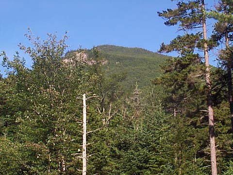
I also got a
look at the southern end of Owl’s Head, which I had been trying to see
through the trees all morning.
After
we reached the Wilderness Trail, the going got easier and we
began to see more and more people, some who were heading into
the wilderness with full backpacking gear, and others who were likely on
short day hikes to nearby spots such as Franconia Falls where they could
picnic and play in the cascades. I passed the spur trail to Franconia
Falls, but decided not to stop as I was ready to get back to the car and
head home. Also, Muffin was probably hungry since she was out
of dog food, so I told her I’d get her a hamburger at McDonald’s.
When
we were almost back at the suspension bridge, a man and his wife stopped us and
asked whether they could take a picture of Muffin in her backpack. They
said they had never seen a dog wearing a backpack before. “Really!” I
replied, thinking that dog packs were fairly common. They took the photo,
which I hope came out all right since Muffin wouldn’t hold still, and were on their way. Actually, a lot of hikers we passed on
the trail made comments about Muffin such as “I see she carries her own
things,” or “if she wants to come, she has to carry her own food.”
Some people with a couple of large dogs even made a comment about how they
needed a backpack for their dog.
At
last, we crossed the suspension bridge and were back at the car. We had made the trip in 3:15, significantly less
than my estimate of 4 to 5 hours. Unlike Thursday, a hundred or so cars now littered the parking
area. Of course, many of their occupants probably never left the Lincoln
Woods area but hung around the East Branch of the Pemigewasset right there
by the road. We drove off, glad to be on our way home, but having enjoyed
the backpacking trip despite, or maybe even partly due to the challenging
day lost in the thunderstorm. |
The
southern end of the Owl’s Head ridge from the Franconia Brook Trail.
Because of the dense woods, we never got a better look at the Owl’s Head
massif from the east. |
|