|
About
halfway to Mt Eisenhower, we passed the barely-noticeable summit of Mt
Franklin. It's not far off the Crawford Path, but we still had a ways to
go and I decided to skip it this time, having been there once
before.
After
going through a fairly flat area around Mt Franklin, the trail started to
descend again, passing through
some scrubby patches, where there were some Bluets growing. Bluets are not
an alpine flower, and are often found in fields, open places, and by the
sides of roads.
At
the junction with the Mt Eisenhower Loop and the Edmands Path, we rounded
a rocky corner and arrived at Red Pond, a small boggy body of water
surrounded by damp and extremely spongy ground. We stopped here for a rest
and a snack, but couldn't get too close to the pond without sinking into
the soft grassy mat. This is not a great place for filtering some water.
Still, it's a pleasant enough spot for a rest, and pretty much sheltered
from the wind it the weather is less than perfect.
The
hike up the summit cone went quickly and we were soon standing on top of
the gently-rounded and open peak. The views were great and so was the
weather, but I wish the powers that be would replace the ugly rusted sign
on the top of the summit cairn. It makes the spot look like a junkyard. A
wooden sign, or even no sign at all, would be much more appealing. In
1999, the last time I was here, it still had a few cancerous-looking
patches of white paint peering out from behind the rust. Today, it was all
rust with the crudely scratched words "We like Ike."
To
the north the ridge stretches out to Mt Washington and beyond. Mts Monroe,
Washington, and Jefferson are all clearly visible |
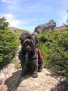
Muffin
on the Crawford Path. We were passing through a scrubby area,
getting close to the Mt Eisenhower Loop junction. |
 |