|
|
|
|
|
Mt
Flume, Mt Liberty |
|
|
|||||||||||||
|
The
day began partly cloudy with some fog and about 65 degrees at the Whitehouse
Trailhead. It got warmer as the day wore on, up to about 85 in the
valley and maybe 70 at the summits. At Mt Flume, fog drifted in and
out, but disappeared by the time I got to Mt Liberty. After the fog went
away, it remained a bit hazy. The Flume Slide Trail had a few muddy spots.
I parked the car at the Whitehouse Trailhead parking lot and started up the trail around 7:00 AM. I was annoyed by three other hikers who were also just starting out and who were smoking further down the parking lot. Luckily, I let them pass me and never saw them again the rest of the day. At the end of the Whitehouse Trail, which was relatively flat and about a half-mile long, I crossed the Pemigewasset River over a bridge and came to the start of the Liberty Spring Trail. I signed my name in the logbook and started up the trail. I followed the Liberty Spring Trail moderately uphill until it reached the Flume Slide Trail. For a long way, the Flume Slide Trail was fairly flat and passed through a mixed hardwood and conifer forest. A few leaves were already beginning to turn yellow. I passed over a few small creeks and eventually reached Flume Brook where I got out my filter and pumped a fresh bottle of water. Lower down this stream flows through the Flume Gorge, but the water wasn’t very wild at this point. Around this spot, I met a father and his teenage son who were climbing the same route, and who ended up talking to me off and on much of the way. They tended to walk a bit faster than I did, but took a lot of long rests, while I walked more slowly but steadily. This meant that I saw them periodically as I caught up to the spot where they were resting. The
Flume Slide Trail climbs moderately and easily for much of its distance.
However, the last 6/10 of a mile goes extremely steeply uphill along the path of
an old rockslide. At first, the slide is very gravelly and loose; later
it’s mostly ledges, many of which you need both hands and feet to climb
up. |
|
|
Sign at the start of the Liberty Spring Trail. The trail begins at a bridge over the Pemigewasset River at the end of the Whitehouse Trail. |
|
|
Crossing Flume Brook. I filtered some water here to fill up a bottle I had already drank. I wasn't sure if I'd find any water up higher. This same stream, further down, flows through the Flume Gorge. |
|
|
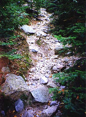
The outwash of the slide on the Flume Slide Trail. At this point, the slide is very narrow and loose and gravelly. |
|
|
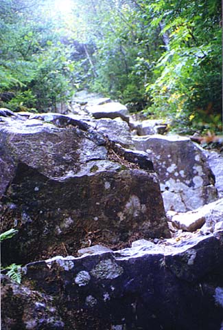
Ledges higher up on the Flume Slide. I needed both hands and feet to climb up some of the ledges, and my poles were often more of a hindrance than a help. |
|
|