|
After
a quiet's night sleep (I'm sure it was noisy up at the crowded
hut), we rose to a thick colorless sky that portended rain. But
since we had no control of the weather, we shrugged it off and
made a quick breakfast of hot oatmeal, cold dog food, power bars,
coffee, and juice, then packed up our belongings. By the time
we had the tent down and stuffed into my backpack, the rain had
begun to fall.
We
walked down to where a small trickle flowed across the trail and
into Zealand Pond, filtered enough water to last for most of the
day, then shouldered our packs and headed down the Ethan Pond
Trail. The trail was wide and flat for a over a mile, following
the bed of an old logging railroad. The thick forest protected
us from most of the rain, and our raincoats and ponchos did the
rest. As we drew near Zealand Notch, the shower began to let up.
When
we broke through the last of the trees out into the open rocky
slopes of Whitehall Mtn, the rain had stopped, but the sky was
still ominously cloudy, and mists hugged the mountaintops like
ethereal gray blankets, obscuring the peaks from our view.
The
notch itself was like a giant's playground, strewn with rocks
that had tumbled down from the slopes above. It reminded me of
the Rampart in Carter Notch. The trail here closely follows the
railroad bed that had been carved into the slopes some 200 feet
above the floor of the notch, and so offered a relatively flat,
secure, and unobstructed passageway. This section of the Ethan
Pond Trail, in my opinion, offers a sensation of being much higher
up in the mountains than you usually get for so little effort.
About
halfway through the notch, we passed the junction with the Zeacliff
Trail, which
drops precipitously to the floor of the notch, then climbs the
steep slopes on the other side to Zeacliff, the virtual end of
a long ridge dominated by Mt Zealand, but linking to Mt Guyot,
the Bonds, the Twins, and Garfield Ridge beyond.
After
a couple of short rests for pictures and snacks, we passed out
of the notch and back into the woods, and once again picked up
the pace in our effort to reach the now nearing Thoreau Falls. |
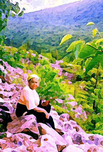
Toi
resting in Zealand Notch. By this point, the rain had begun to
let up, which made it easier to appreciate the view in the notch. |
|